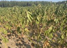
El Nino could provide relief for drought-stricken farms
STARKVILLE, Miss. -- Cool temperatures and rainfall are two things most of Mississippi has not seen lately.
This winter, however, that could change and help farms that have taken a hit from extreme drought if anticipated El Nino conditions play out. But the rains will not arrive quickly enough to save this year’s crop for some growers.
The southwest quadrant of the state is currently in what the U.S. Drought Monitor report classifies as a D-4 (exceptional drought) zone, while other portions near or below Interstate 20 are in D-3 or D-2 zones.
“We have several row crops that just are not going to yield this year,” said Corey Bryant, an agronomist and soil fertility specialist with the Mississippi State University Extension Service. “Some of the people I’ve talked to in the southwest part of the state are looking at the potential of not having anything to harvest. That is financially devastating to a lot of these growers, especially those who are just getting started.”
Tyler Soignier, MSU research and Extension program manager based at the E.G. Morrison Brown Loam Branch Experiment Station in Hinds County, said a majority of growers in central Mississippi are dealing with yield reduction across all their row crops due to the extreme drought.
“We had good growing conditions and adequate rainfall throughout May and June, but since July 9, we have not received a rainfall event over half an inch,” Soignier said. “The majority of our row crops initially looked good, but as the dry and hot weather continued throughout the summer, we began to notice that our plants were not able to fill out the fruit they had set as they began to reach physiological maturity. With the vast majority of our growers in this region having dryland fields, we have seen devastating yield loss.”
Mike Brown, state climatologist and meteorology professor at MSU, said previous El Nino winters have contributed to some of the coolest annual temperatures and wettest years on record in Starkville dating back nearly 135 years.
“The El Nino in 1997 brought about our fourth coolest annual temperature to date,” Brown said. “The events of 1979 and 1983 were more pronounced, with 1983 being the third wettest and 1979 the fourth wettest years on record. This is not to say that we will see record rain or temperatures, but chances are better for a cooler and wetter winter, which is much needed to dig out of the current drought.”
Brown explained the formation of El Nino patterns as an interaction between the atmosphere and the ocean.
“Generally, the trade winds in the southern Pacific blow east to west -- just south of the equator -- from around Peru toward northern Australia. When there is higher atmospheric pressure over Australia, these trade winds tend to weaken or can even reverse direction,” he said. “This helps to warm the water in the central and eastern portions of the Pacific due to less upwelling of cooler water from the coast of Peru.
“The reduced upwelling and warmer waters are conducive to more thunderstorms in the central and eastern Pacific due to increased instability,” he said.
Brown further noted the warmer surface temperatures create a gradient that helps keep jet streams -- horizontal air currents that separate air masses and transport moisture and heat -- closer to the equator.
“In a ‘normal’ winter, the jet stream is found several hundred miles to our north. In an El Nino winter, the jet stream is a bit further south, bringing more storms, rain and slightly cooler temperatures to the Southeast U.S.,” he said. “Where the jet stream should be in the winter is replaced by an area of high pressure, which is normally associated with slightly above normal temperatures and dry conditions.
“That is not to say it will be warmer 400 miles to the north than we are,” Brown added, “but it will likely be warmer than normal for those locations just as it may be cooler than normal for us.”
Bryant said farms impacted by the drought would reap long-term benefits of a wet winter, but a lot of rainfall is needed to restore soil moisture profiles to deeper depths that can support better yields in 2024.
“Our growers in zones where the drought is the worst, even if they have irrigation capabilities, that irrigation is still only recharging the soil profile to a depth of maybe 2 feet, depending on the soil type,” he said. “Extended rainfall can provide relief and recharge that moisture profile down to 4 feet or deeper. If that happens, when we get into next spring and look at planting, we have a full moisture profile to get next year’s crop started and help us delay irrigation further into the season.”
Growers who apply fertilizer in the fall risk having nutrients leach from the soil during wet winters.
“We already do not recommend putting out phosphorous and potassium in the fall because winter is usually our wettest time of the year. Additional rainfall could cause increased leaching, and at that point our growers are essentially wasting money,” Bryant said.
Another issue is that many growers take soil samples when fields are drier and easier to get into. Those soil test results may not be accurate after winter rainfall and leaching events.


